All rivers go to the sea,
yet never does the sea become full.
To the place where they go,
the rivers keep on going.
- Ecclesiastes 1:7
|
Disambiguation: This Page is about the Five Mile River in southwestern Connecticut, not the the Five Mile River in northeastern Connecticut.
About This Page
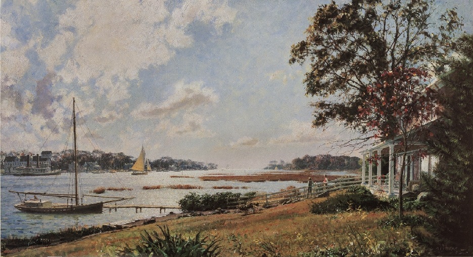
In 1989, Peter and Marilyn Carroll Biggins and family purchased a house newly-built by St. John Associates on an acre of land in Darien, Connecticut, at 230 Old Kings Highway North. The house is on the mill run for The Red Mill at Five Mile River. This was the first house ever built on this part of the site. The only previous structures were a gristmill (the Red Mill) and a sawmill. The street is part of the original Kings Highway between Boston and Charleston, South Carolina. Darien was called Middlesex, part of Stamford, until 1820.
Next door, on the other side of the mill run, at 222 Old Kings Highway North, is a house built in 1880, when the Red Mill was still standing.
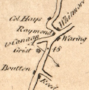
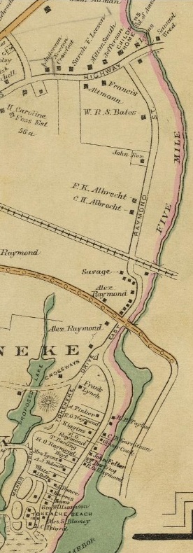
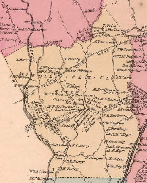
Mile 48. From 1789 Colles atlas, Map 4, page 7, showing the Old Post Road, now Old Kings Highway North, the Red Mill ( Grist *), the Five Mile River (southbound squiggly arrow), and 48 miles from Federal Hall. Present day streets: Richards Avenue to the north (A to Canaan) and Rowayton Avenue and Raymond Street to the south. |
|
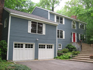
230 Old Kings Highway North, Darien, Connecticut. March 2006. |
|
Back of 230 Old Kings Highway North. February 2023. Photo by Gina Nichols. |
|
Walking Down the Five Mile River
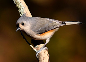
Tufted titmouse (Baeolophous bicolor). Official bird of PetersPioneers. The song is a whistled peter-peter-peter-pete. They nest in a hole in a tree. |
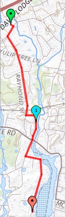
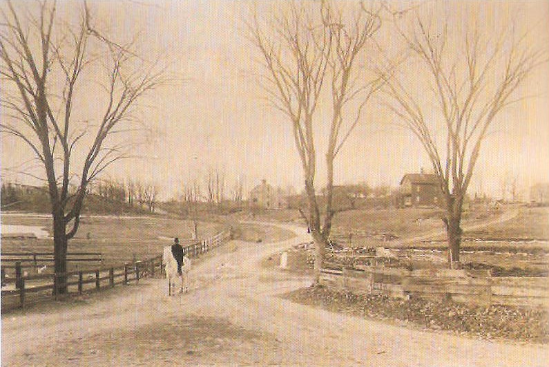
In 1997, Peter had an annual physical and the doctor suggested he exercise regularly. As a result, Peter started walking four miles a day down to Long Island Sound. His normal route is down Raymond Street and Five Mile River Road to the mail boxes near the end of Five Mile River Road, and back. Initially, the walk took an hour. After 20 years, however, it was up to an hour and 15 minutes.
Walking the same route around sunrise day after day, you get to learn something about the route and know some of the residents along the way. And you wonder about the part of the river you don't see. In 2020, he decided to start this research on the river.
You also learn that the most common birdsong on the last two miles of the river is that of the tufted titmouse (Baeolophous bicolor), official bird of PetersPioneers. The song is a whistled peter-peter-peter-pete.
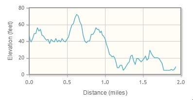
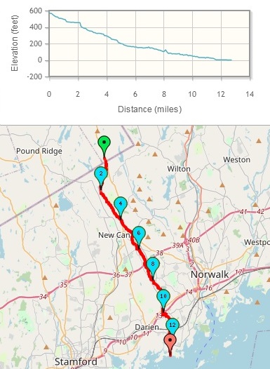
Downriver elevation of Peter's walk. Highest point is Mount Pleasant. See: Map Pedometer. |
|
|
|
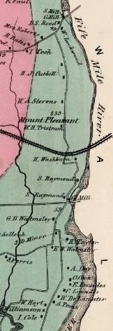
1867 map of Peter's walk showing Mount Pleasant. |
|
Some Old Maps of the Five Mile River
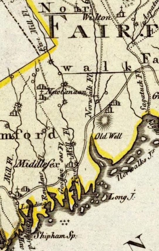
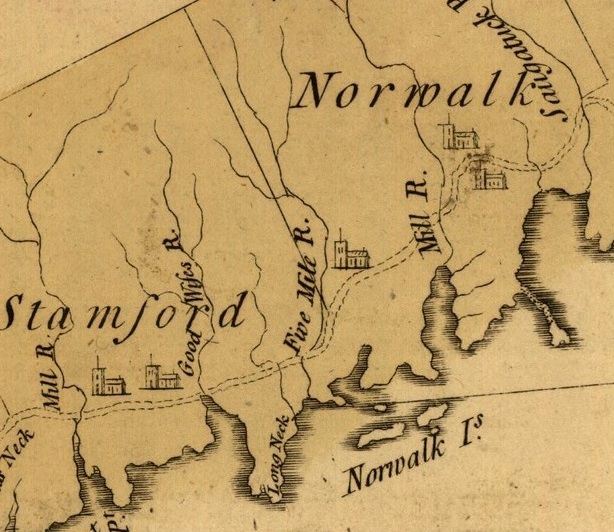
Source: Part of Map of Connecticut, showing the Five Mile River (Five Mill Fl.), nearby rivers, grist and saw mills, and the old Post Road. Fl. is for fluss, German for river. Rowdens River is Noroton River. Middlesex is Darien. Old Well is South Norwalk. Map Legend. Designed by Daniel Friedrich Sotzmann from Berlin, Germany, based on maps by Blodget, Carey, and Ristow collected by Christoph Daniel Ebeling from Hamburg, Germany. Published by Carl Ernest Bohn in Berlin, Germany, 1796. |
|
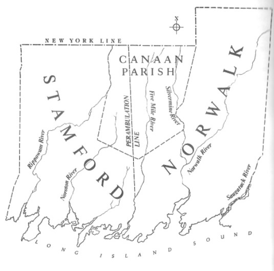
Map showing how Canaan Parish was created from Stamford and Norwalk in 1731. Source: Portrait of New Canaan: The History of a Connecticut Town, by Mary Louise King, 1981, p. 26. |
| |
|
Inhabitants, 16000 BC
Following the glacial melting of the Laurentide Ice Sheet, new vegetation and warmer climate caused new New England to become inhabitable by early human settlers. This new climate, combined with an ample supply of hard volcanic rock and other natural features, created an ideal area for human settlement. These settlers fashioned tools, such as arrowheads, from surficial rhyolite deposits they found near what could have been their river valley settlements. Early human settlers could have populated these river valleys. Source: Geology of New England
The River Book
The Environmental Committee of The Junior League of Stamford-Norwalk published a study guide on river flood plains: The River Book, A Study Guide to the River and Its Environment. The Five Mile River was used as an illustration of a river's diverse wetland species and its role as a refuge for many types of wild life. Included was a history of the Five Mile River. In the 1980s and 1990s, the study guide was used extensively in the spring and fall for river study programs for Darien and Norwalk 4th and 5th graders and other groups. Following is an excerpt of the history of the Five Mile River (1977 edition, pages 33-36).
Indians
The Indians inhabiting the Five Mile River area were a physically large people and included the generally peaceful Siwanoy tribe. The Siwanoy lived in small villages of bark-covered wigwams. They made wampum from clam and oyster shells found in abundance at the estuary of the river, and fashioned arrowheads and other stone implements for a relatively simple life devoted to hunting, fishing, and the farming of corn.
At the estuary on the west side of the Five Mile River is Butler's Island, where one may still find occasional arrowheads and see the remains of a Siwanoy pothole, a large rock scooped out in the center and used to grind corn and other seeds. The rock is directly beside what must have been a giant oak. It is believed that a stone was hung from a branch on the tree at just the right height to permit the stone and pothole to work like a pestle and mortar.
Huge buried piles of oyster and clam shells indicate a probably major Siwanoy encampment just to the west of the Five Mile River in the Tokeneke area of woodlands, meadows, coves, and tidewater streams. Chief Tokeneke is the name and mark of a sachem, of chief, of a people who were here before the earliest white settlement. His name appears on some original land deeds in the state archives.
The peaceful Siwanoy ("The South People") were surrounded by less pleasant neighbors. To the east were the warlike Pequots and to the northwest the savage Mohawks. For protection the Siwanoy joined other small tribes throughout Westchester in the "Wappinger Confederacy," a league which more or less controlled the land lying between the Saugatuck and Hudson Rivers. It is thought that the Five Mile River was used by the Siwanoy as a guide in their travels north to attend those council meetings with their brother clans and to hunt.
Colonists
Early settlers were attracted to land near the Five Mile River because of the good fishing. Each settler received a houselot, woodland, and pasture. Common lands were reserved for the grazing of cattle. But early colonial writers refer to the shores of the Five Mile River as being infested with smugglers and squatters who were in constant conflict with the Indians and the early white settlers.
The Five Mile River was, in fact, a boundary line in the earliest local agreements signed by the English colonists and the Indians. In 1640 a deed was signed to land extending from the Five Mile River on the east to the Mianus River on the west and from Long Island Sound to about 10 miles north. The buyer was Captain Nathaniel Turner, an agent for the New Haven Colony. The sellers were Ponus, Sagamore of the Toquams, and his brother Wascussee, Sagamore of the Shippan ("shore where the sea begins"). The mark of the Ponus, a medicine man whose name translates "he who uses herbs," was a lightning streak. The mark of the Wascussee was a bow and arrow. The price of the transaction was 12 coats, 12 hoes, 12 hatchets, 12 mirrors, 12 knives, 2 kettles, and 4 fathoms of white wampum.
In 1640(?) the Five Mile River was the eastern boundary of the Norwalk land purchased from the Indians by Roger Ludlow and Captain Daniel Patrick. But these lands were not settled until 1650.
In 1645 another Indian sale completed the purchase of what is now Darien. Piamikin, sagamore of "Roaton," sold much of the land between the Five Mile and Goodwives rivers--including Long Neck point, Great Island, Salem Straits, and Delafield Woods--to Andrew Ward and Richard law of Stamford for 4 coats and some tobacco. This land was purchased because the original colony of Stamford and Noroton had grown from 28 families in 1638 to 59 by the end of 1642. In the sales agreement Piamikin stipulated that the English must agree not to build houses on the land, for he feared the English hogs would run in the Indian corn fields and ruin the crops.
Boundary disputes on the river were common. Because Piamikin had sold some of the land bordering the Five Mile River to both Stamford and Norwalk, there were many bitter arguments over the right of Norwalk men to cut hay west of the river.
In 1685 the land at Runkinheag (now called Tokeneke) was subdivided into lots of several acres apiece and assigned to men who were living in Stamford center. The brothers John and Jonathon Bates were among the first to be granted land in this area.
As new generations grew up in Stamford, fathers dipped into their land holdings and turned over lots on the outskirts of town to their sons and grandsons. One such property near the Five Mile River is at 148 Old Kings Highway North at the corner of East Trail. The land records of 1705 show that John Bates gave his son Jonathon a wedding present of that location on the "Country Road" and included an unfinished house on the property.
Rivers are often used for transportation, but there is no evidence that the Five Mile River was used extensively in this fashion. Rather, a road from new Canaan to the mouth of the river called "the road to the Five Mile River Landing," was used to transport produce. Its purpose was to reach port by the best route then available, and it followed the line of the river fairly closely.
The river did, however, become a shipping center for the area, and it could be said that the Five Mile River was the chief reason for the existence of Rowayton. Soon after Rowayton was settled in the 1780s, a flourishing commerce brew up. Farmers as far away as New Canaan brought there produce to be loaded on sailing packets and carried to New York to be sold or traded for goods.
The river also had a series of mills. There were two grist mills on the Darien side of the river: one at White Bridge and another on a brook that runs into Scott's Cove. There was also a grist mill on Chasmars Pond and a mill farther up the river near the bridge on Kings Highway.
In New Canaan, there were seven mills. John Brotherhood's parking lot is the site of William Boult's 1761 cider mill. The 1782 estate inventory of Peter Smith indicates a cider mill on his 300 acres north of Michigan Pond. On Summer Street Weed's flour mill was in full blast about 1824, and Benedict Wood had a large grist mill not far away. In 1848 Anthony Comstock replaced an old saw mill on Mud (or Mill) Pond with a new mill.
But the most information is known (from a history of New Canaan 1801-1901) about the saw, grist, and cider mill on Mill Pond owned by Justus Hoyt, the blind miller of New Canaan.
Hoyt's mill was the old Millport Mill on what was known as Hanford's Millpath (now Millport Avenue), north of the present Lakeview Cemetery (which was deeded as a cemetery by Hoyt), and replaced the first mill on Mill Pond. The new mill was built by Levi Hanford in 1757. He sold the mill and pond to Cook St. John, who later sold it in 1852 to Justus Hoyt, who lost his eyesight in an accident when he was 9 years old.
Justus Hoyt took his son-in-law Lewis St. John Olmsted into partnership. Olmsted then took Justus Fitch Hoyt on as a partner to his thriving flour mill until Olmsted sold his grist and saw mill to him on July 11, 1876. Although the mill has long since disappeared, the spillways and foundations are still visible.
King's Highway. King's Highway North, the road where we park to walk on the Traendly flood plain, was the first "Colonial Road" and united New York and Boston. In 1679 it was recognized as an indispensable artery connecting the coastal communities when the General Assembly ordered that "the country road or King's highway connecting the plantations be cleared to one rod wide. Then in 1703 an order was issued under the Act of the Provinces relating to highways to survey and lay out a continuous road to follow the Indian trails and the cartways already in existence. For many years after, this improved road was still little more than a cartway full of rocks, holes,and stumps.
In 1722 a stagecoach schedule was established between Boston and new York once very two weeks. This schedule was discontinued during the Revolution when British forces occupied new York. But by 1787 commerce had grown, and the New York-Boston stage made three trips a week.
Among the many famous men who travelled this road were Paul Revere, John Hancock, and General Lafayette. John Adams drove along this spot in 1774 on his way to the First Continental Congress. He was accompanied by the other delegates from Massachusetts: Samuel Adams, Robert Paine, and Thomas Cushing.
George Washington passed this way three times. He was interested in the stone fences along the way and remarked upon the many droves of beef cattle and flocks of sheep he saw being driven along this area to the New York market.
Benjamin Franklin, our first postmaster general, travelled the road measuring each mile of the improved road with s special wheel, which was attached to his wagon. At the end of every mile he drove into the ground a wooden stake which was later replaced by a solid milestone.
Modern Man
In the early part of the 19th century, Rowayton became the center of a flourishing oyster industry. For the first time oysters were "planted" off the mouth of the Five Mile River. In the "planting" process oysters were added to the natural beds during the spawning season, thus increasing the number of grown oysters that would eventually be harvested.
Rowayton also kept up with the growing needs of the shipping industry by becoming the home of several shipbuilding yards. Eventually, however, with the advent of the railroad, the sailing packets slowly disappeared from the scene; and the railroad became the main means of transportation for the many industries (such as the carriage and felt hat factories) which had, along with the grist mills, developed around the Five Mile River.
Commercial and private fishing today is very active in Rowayton Harbor and in the estuary of the Five Mile River. Oystering is still carried on. Heavy steel plates are dragged along the harbor floor, and the oysters are taken on timed trips to the greater tidal areas near the Norwalk Islands and near Bridgeport and New Haven.
Clamming too is a very important trade. Clams are taken out of the Norwalk Islands, where the stronger tidal currents allow a clam to cleanse itself of all pollutants in 3 rainless days. (Heavy rains seem to wash dangerous products into the water.)
Menhaden (or bunker) are very important bait fish caught in the river, where the fearsome and ravenous bluefish (which require more oxygen and deeper water) have chased them. Cods (Tommy cods or frost fish), flounder, crabs, lobsters, and eels are also caught.
Upriver is mostly residential, with some industrial (the notable examples are the Holiday Inn, Old MacDonald's Farm, and the New Canaan Sewage Treatment Plant).
|
Nearby Rivers
The Five Mile River is one of a number of small coastal rivers of varying length that flow under the Post Road (US-1), the New Haven Railroad, the Merritt Parkway (CT-15), and the Connecticut Turnpike (I-95) into Long Island Sound in southwest Connecticut. Rivers within fives miles east and west are:
- Rippowam (Mill) River, 17 miles in New Canaan and Stamford ending in Stamford Harbor. Rolling Mill; Saw Mill and Wire Mill north of Cedar Heights Road, off Wire Mill Road
- Noroton River, 9.5 miles in New Canaan and along the Darien/Stamford border, ending in the Cove. Cove Mill on Stamford side of Holly Pond and Cove Harbor; Liquorice Mill, north of I-95; Grist Mill and Saw Mill north of Jelliff Mill Road in New Canaan
- Goodwives River, 6 miles in Darien. Grist Mill, at Rings End. Joined by Stony Brook
- Five Mile River, 12 miles in New York, New Canaan, Norwalk, and the Norwalk/Darien border, ending in Rowayton Harbor. Fourteen old mills and factories
- Norwalk River, 23 miles in Ridgefield, Brannchville, Georgetown, Wilton, and Norwalk, ending in Norwalk Harbor. Multiple mills in Georgetown. Winnipauk Mills in Norwalk. Joined by Silvermine River north of Broad Street at Deering Pond
- Saugatuck River, 24 miles from Sugar Hollow Pond in southwest Danbury to Redding, Weston, and Westport.
The 1789 Map of the Old Post Road by Christopher Colles includes mile markers on the Post Road starting at the southern tip of Manhattan. The Five Mile River is at mile marker 48. The Five Mile River is east of the Rippowam River by 6.2 miles, the Noroton River by 4.0 miles, the Goodwives River by 1.0 miles. It is west of the Norwalk River by 3.2 miles, the Saugatuck River by 7.6 miles.
What's in a Name?
Mary Louise King says that the Five Mile River was so-named because of its distance from the Saugatuck River (Portrait of New Canaan: The History of a Connecticut Town,, 1981, p. 8). The Five Mile River is five miles west of the Saugatuck River, measured along Long Island Sound. But, it is also five miles east of the Rippowam (Mill) River.
Distance of five miles from the Saugatuck River to the Five Mile River. See: Map Pedometer. |

Distance of five miles from the Rippowam River to the Five Mile River. See: Map Pedometer. |
Frank Raymond dispels the myth that the original name of the river was Five Mill River. He says the river was referred to as the Five Mill River in 1656, but there were no mills on the river at that time. It was obviously a misspelling (Rowayton on the Half Shell, 1990, p. 16).
The German map shown above, which relies on American map makers, uses Mill instead of Mile in naming the river. But, it shows nine mills on the river.
On Google Maps and the U.S. Geological Survey, the name is Fivemile River.
Length and elevation of the Five Mile River. See: Map 922093 at Map Pedometer. |
From Vista, New York, to Long Island Sound
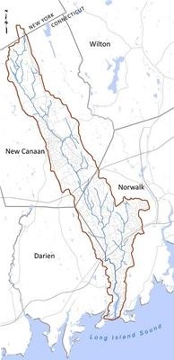
The Five Mile River is 12.7 miles long starting at its headwaters in New York State and flowing into Long Island Sound.
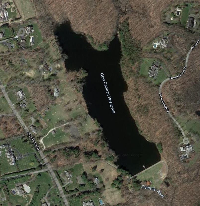
The Five Mile River watershed consists of a network of small streams and wetlands buffered by meadows and undeveloped forest. Drinking water is drawn from the New Canaan Reservoir, which marks the downstream extent of the headwater region. Farther downstream, the river passes through residential neighborhoods and dense commercial centers in New Canaan, Norwalk, and Darien. The river forms the border between Darien and Norwalk south of the Post Road.
The headwaters of the Five Mile River are about 300 yards north of the Connecticut/New York border (Puddin Hill Road) and 40 yards west of Smith Ridge Road, in the Vista hamlet of Lewisboro town, in Westchester County, New York.
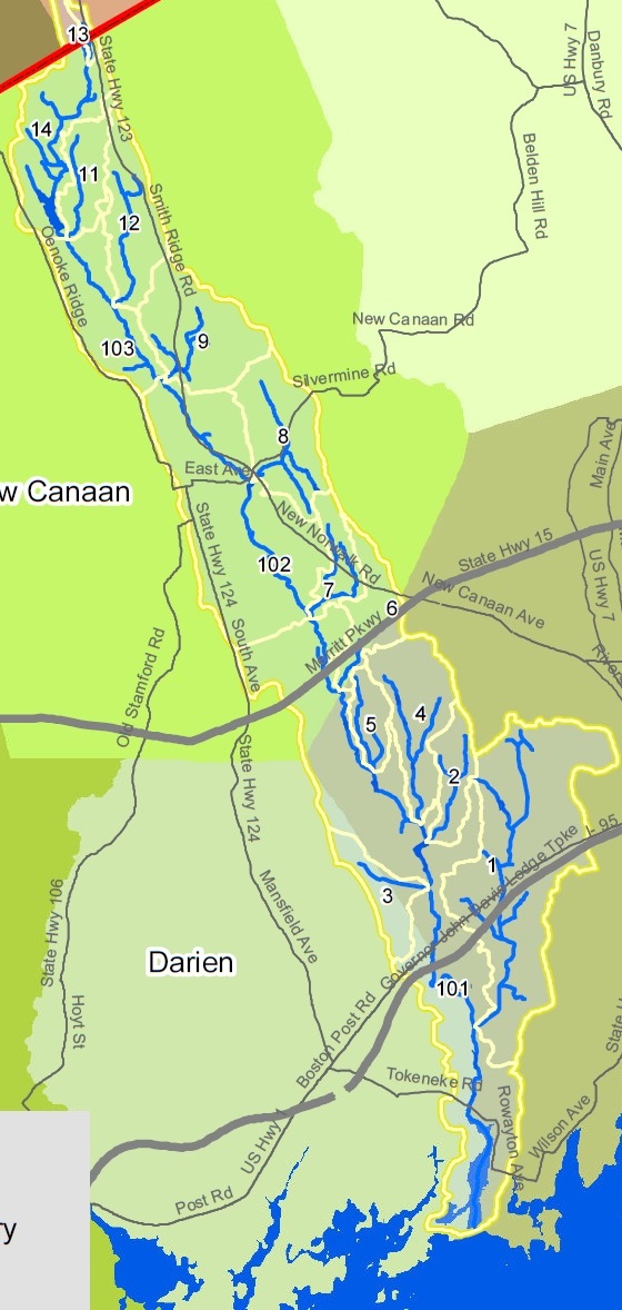
There are 20 crossings of the Five Mile River, including :
- Puddin Hill Road, the New York/Connecticut border since 1731
- CT-15, the Merritt Parkway, an expressway limited to cars, built in 1938
- I-95, the longest north-south Interstate, 1,900 miles from Maine to Florida.
- US-1, a federal highway running from Maine to Florida, replaced the Old Post Road in 1807
- the Old Post Road, now Old Kings Highway in Darien and Flax Hill Road in Norwalk
- the New York, New Haven, and Hartford Railroad, built in 1848
There are also four private bridges that cross the river. From 1895 to 1933, a trolley crossed the river at White Bridge.
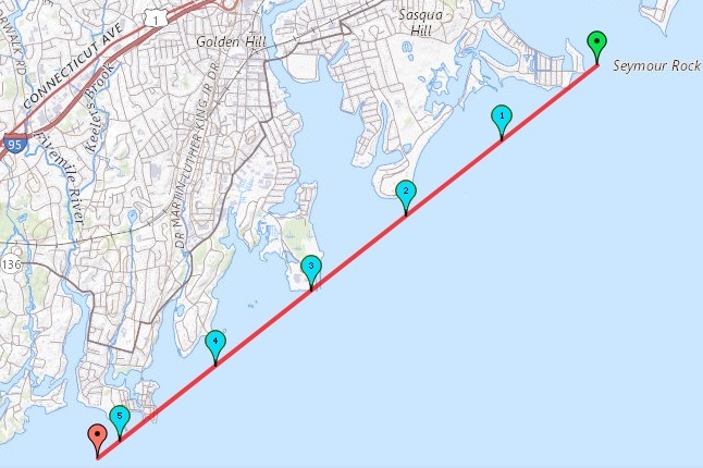
The estuary, or mouth, of the river is at Long Island Sound, 12.7 miles from the headwaters in New York State. You can easily see the North Shore of Long Island, about seven miles away. In the estuary, oyster farming was a major industry, peaking in the early 20th century. There were two dramatic, rocky projections - one on Butler's Island, and the other slightly upriver, formerly known as the Loading Rock. It was used for loading cargo sloops in the 18th and 19th centuries. The Loading Rock as well as other local coastal scenes were favorites of John Frederick Kensett (1816-1872). The Metropolitan Museum holds several paintings of the Five Mile River in its Kensett collection. See Marian Castelli's Loading Rock.
Below is a table showing points of interest on the Five Mile River, using Google Maps, 1867 maps of New Canaan,
Norwalk,
Darien, and an 1856
Fairfield County . Twenty crossings (grey) were found along the way on present-day maps. Fourteen old mills and factories (bold) were drawing water power from the river on the 1867 maps. Elevation is 565 feet above sea level at the headwaters, down to sea level at Long Islad Sound (The National Map of USGS).
| Vista, Lewisboro, NY |
New Canaan, CT |
Norwalk, CT |
Darien, CT |
Water |
| Right Bank |
Five Mile River
|
Left Bank |
| Scenic Drive |
Headwaters - elevation 565 feet |
NY-123 - Smith Ridge Road,
Vista, Lewisboro, New York/td>
|
| Puddin Hill Road, New York/Connecticut border since 1731 - mile 0.1 |
| Lukes Wood Road |
River |
CT-123 - Smith Ridge Road |
| Michigan Road - mile 1.2 |
Lukes Wood Road,
CT-124 Oenoke Ridge Road |
River
New Canaan Reservoir - 449 feet |
CT-123 - Smith Ridge Road
Summersweet Lane |
| New Canaan Reservoir Dam, concrete, 470 feet long, 44 feet high, completed in 1898 - mile 2.1 |
| CT-124 Oenoke Ridge Road |
River |
CT-123 - Smith Ridge Road
Indian Rock Road |
| Country Club Road - mile 3.0 |
| CT-124 Oenoke Ridge Road |
River |
Lambert Road |
| Lambert Road - mile 3.2 |
Lambert Road,
CT-124 Oenoke Ridge Road,
Parade Hill Road,
Riverbank Court
Old Saw Mill |
River |
Brookwood Lane,
CT-123 - Smith Ridge Road,
Glen Drive |
| CT-123 - Smith Ridge Road - mile 4.3 |
| CT-123 - New Norwalk Road |
River |
River Road
Old Grist Mill |
| CT-123 - New Norwalk Road and Locust Avenue and Brushy Ridge Road - mile 4.6 |
Summer Street,
Main Street |
River |
CT-123 - New Norwalk Road,
Old Kings Highway |
| Brook Street - mile 4.7 |
Summer Street,
Main Street
Old Saw Mill |
River |
CT-123 - New Norwalk Road,
Old Kings Highway |
| CT-106 - East Avenue - mile 5.0 |
Millport Avenue (foot bridge),
Main Street
Old Saw Mill, Grist Mill |
River,
Mill Pond - 200 feet |
Mill Pond Park,
CT-123 - New Norwalk Road,
Old Kings Highway |
| Lakeview Avenue - mile 5.2 |
Millport Avenue,
Main Street, Down River Road |
River |
Lakeview Cemetery (private bridge),
Wastewater Treatment Plant (private bridge),
CT-123 - New Norwalk Road,
Old Kings Highway |
| Old Norwalk Road - mile 5.9 |
| White Oak Shade Road |
River |
Kiwanis Park,
Marvin Ridge Road
Hidden Brook |
| Nursery Road - mile 6.8 |
| White Oak Shade Road |
River |
Marvin Ridge Road |
CT-15 - Merritt Parkway - mile 7.0
Built in 1938 |
White Oak Shade Road,
White Oak Shade Lane |
River |
Marvin Ridge Road |
Old Saw Mill & Axe Helve Factory
West Norwalk Road |
River |
Weed Avenue, Grey Squirrel Drive,
Meeting Grove Lane, private bridge/dam |
| Old Rock Lane - mile 7.4 |
| West Norwalk Road |
River,
Millard Pond |
Pin Oak Lane
Old Feed Mill, Saw Mill |
| Millard Pond Dam, masonry, 75 feet long, 17 feet high - mile 7.6 |
Old Sash & Blind Factory
West Norwalk Road,
West Lake Court |
River,
Florsheim Pond |
Princes Pine Road,
Alewives Road,
Fillow Street |
| Florsheim Pond Dam, concrete, 130 feet long, 10 feet high, completed in 1874 - mile 8.2 |
Old Feed Mill, Saw Mill
West Norwalk Road,
West Lake Court |
River |
Princes Pine Road,
Pin Oak Lane,
Alewives Road,
Fillow Street |
| Fillow Street - mile 8.3 |
West Norwalk Road
Libby Road,
Watering Lane,
Morehouse Lane |
River |
Geneva Road, Bonnybrook Road and Trail,
Holy Ghost Fathers (Hanford) Brook
St. John Cemetery (Marilyn Biggins 1940-2020)
Norwalk Community College
Richards Avenue |
West Cedar Street - mile 9.2
Narrow stone arch bridge built in 1910 with adjacent foot bridge replaced by wider bridge in 2025 |
West Norwalk Road, Riverwalk Lane,
bridge to parking lot,
covered foot bridge at River Park
(former Old MacDonald s Farm) |
River |
Richards Avenue, Beechwood Road,
private bridge (2016) at Mallards Landing |
US-1 - Post Road in Darien - Connecticut Avenue in Norwalk - mile 9.9
Replaced Old Post Road in 1807
US-1 runs 2,369 miles from Key West to the Canadian border
Darien/Norwalk border, the Perambulation Line, proceeded 37.5 degrees northwest from bridge after 1807 |
| I-95 northbound Exit 13 ramp, goes under the I-95 bridge alongside the River |
River
Darien/Norwalk border after 1807 |
Costco
Richards Avenue |
I-95 (6 lanes) - mile 10.0
Darien Bypass built in 1952-54
Runs 1,908 miles from Miami to the Canadian border |
Red Mill Lane,
Old Saw Mill,
mill run remnant,
Old Grist Mill (foundation remnant) |
River
Darien/Norwalk border after 1807
Old Mill Pond |
Richards Avenue,
large dam remnant,
small brook from Getner Farms,
Shadybrook Lane |
Old Kings Highway North in Darien - Flax Hill Road in Norwalk (The Kings Highway, Country Road) - mile 10.4
The 1789 Colles atlas shows the river is 48 miles from Federal Hall
Part of the colonial Kings Highway, 1,300-mile road ordered by Charles II, king of England from 1660 to 1685
Post-riders carrying mail between Boston and New York City crossed here monthly on horseback starting in 1673
Stagecoach between Boston and New York City crossed here fortnightly starting in 1772
George Washington crossed here in 1756, 1775-76, and 1789, as Colonel, General, and President
Darien/Norwalk border, the Perambulation Line, proceeded 37.5 degrees northwest from bridge from 1686 to 1807
Bridge rebuilt in 1994 |
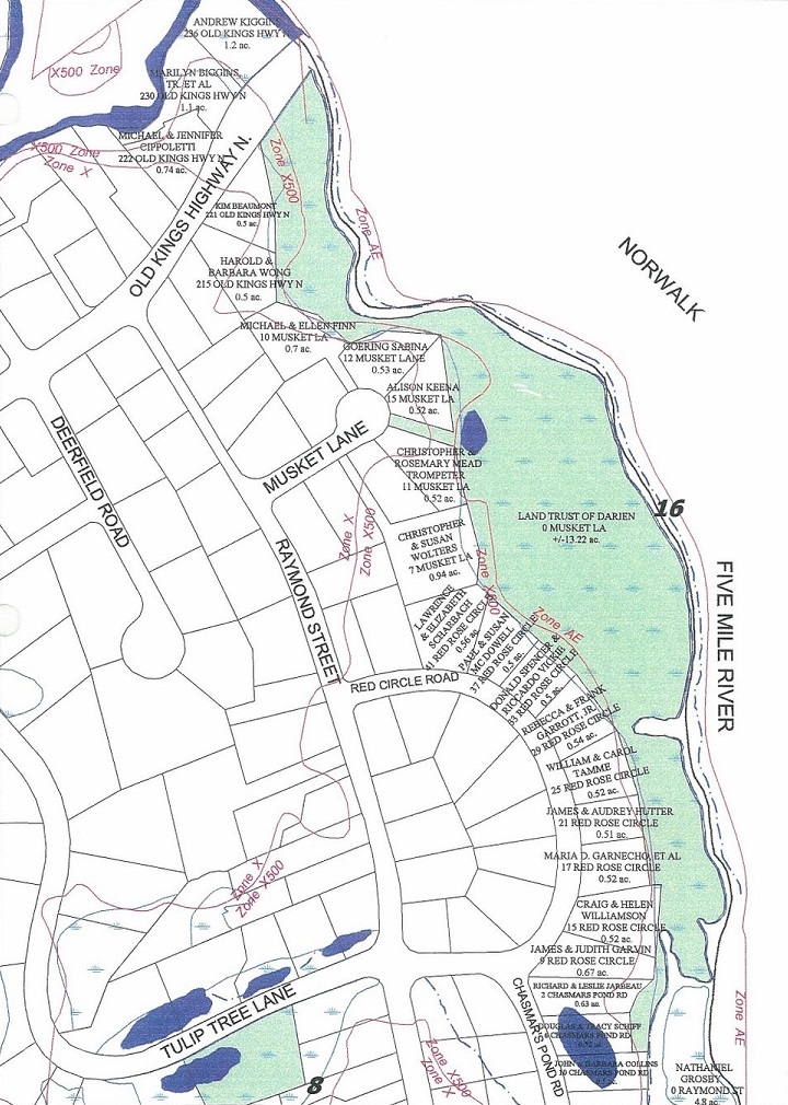
Darien Land Trust: Traendly Flood Plains
Raymond Street,
Musket Lane, Red Rose Circle,
Chasmers Pond Road,
Mount Pleasant |
River
Darien/Norwalk border
Chasmers Pond |
Rowayton Avenue,
Cottontail Road, Pheasant Lane,
Brookside/Five Mile River Cemetery 1723
(Rev. Moses Mather 1719-1896),
Keelers Brook, Union Cemetery 1846,
Rowayton Court |
New York, New Haven, and Hartford Railroad - mile 11.3
Built in 1848 |
Raymond Street
Old Grist Mill |
River
Darien/Norwalk border
"Top of the salt" |
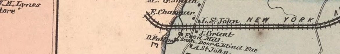
Old Feed Mill and Sash, Door & Blind Factory
Rowayton Avenue, Carolyn Court (bridge)
McKendry Court, Jacob Street |
| White Bridge. CT-136 - Tokeneke Road in Darien - Cudlipp Street in Norwalk - mile 11.6 |
| From 1895 to 1933, a trolley line crossed on a trestle on its way between Darien and Rowayton |
Five Mile River Road,
Loading Rock, Contentment/Butlers Island |
Mouth of the River
Long Island Sound Inlet
Darien/Norwalk border
Five Mile River Harbor
Sea Level - Tidal (Tides) |
Cudlipp Street,
Rowayton Avenue, Pinkney Park,
Rowayton Historical Society
Shakespeare on the Sound
Rowayton village |
Long Island Sound - mile 12.7
⇐ Rippowam (Mill) River is five miles west - Saugatuck River is five miles east ⇒
Greens Ledge Light, built in 1902, one mile from shore
6.6 miles across the Sound to Eatons Neck Point on the North Shore of Long Island |
Notes:
1. The land north of the New York/Connecticut border was part of Connecticut prior to 1731.
2. New Canaan was part of Stamford and Norwalk prior to 1801
3. Darien was part of Stamford prior to 1820. |
Headwaters
The headwaters of a river or stream is the farthest place in that river or stream from its estuary or downstream confluence with another river. It may be in an area that is more marsh-like or swamp-like, in which the "uppermost" or most remote section of the marsh or swamp would be the true source. Swamps consist of saturated soils or standing water and are dominated by water-tolerant woody vegetation such as shrubs, bushes, and trees.
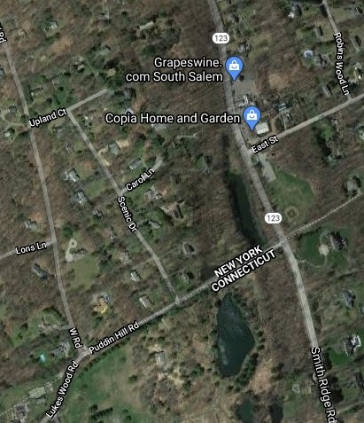
The headwaters of the Five Mile River is about 300 yards north of the Connecticut/New York border (present-day Puddin Hill Road) and 40 yards west of present-day Smith Ridge Road, in the Vista section of Lewisboro, New York. The headwaters of the Five Mile River appears to be swamp-like. It is accessible via a small road across from 475 Smith Ridge Road, Vista, New York (South Salem post office). This is the address of Copia Home & Garden, owned and operated by Peter and Jenn Cipriano, graduates of Cornell s horticultural program.
1867 New Canaan Map of the headwaters of the Five Mile River. |
|
2020 Google Map of the headwaters of the Five Mile River. |
|
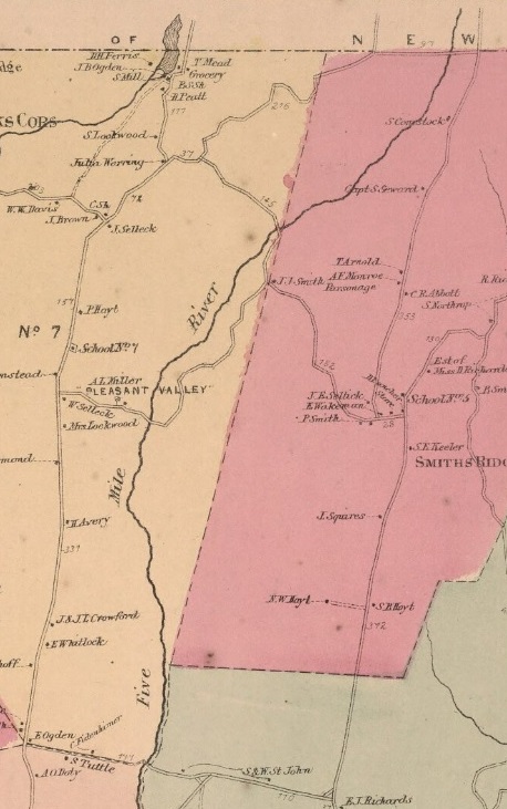
1867 New Canaan Map of the first three miles of the Five Mile River. To the left of the river is present-day Oenoke Ridge Road, south of J. Selleck, and Lake Woods Road. To the right of the river is Smith Ridge Road. The crossroads from north to south are Michigan Road, Summersweet Lane in Pleasant Valley, and present-day Country Club Road. The Summersweet Lane crossing was replaced by the New Canaan Reservoir. |
New Canaan Reservoir
New Canaan
|
|
1867 New Canaan Map.
On the left side of the map is the central area of New Canaan. East-west streets are Elm Street, Cherry Street, and Maple Street. North-south streets are Park Street, South Avenue, and Main Street.
Main Street north angles northwest, then become Oenoke Ridge road as it heads north. Main Street south parallels the Five Mile River and becomes White Oak Shade Road and, eventually, West Norwalk Road.
At the top of the map are two mills on the Five Mile River, at the foot of present-day Parade Hill Road. A saw mill was north of the Smith Ridge Road bridge. A grist mill was to the south of that bridge. Forest Street is west of the river. River Street is to the east.
Locust Avenue runs northeast from Main Street and crosses the Five Mile River, after which it becomes Brushy Ridge Road.
Summer Street runs south from Locust Avenue, crosses East Avenue, and ends at lakeview Avenue. Today, Brook Street comes off Summer Street between Locust Street and East Avenue and crosses the Five Mile River.
East Avenue runs east from Main Street and crosses the Five Mile River. To the north of East Avenue is a saw mill. To the south of East Avenue and the present-day Mill Pond, are a saw mill and a grist mill. Alongside the Mill Pond is Millport Avenue. Crossing Millport is Lakeview Avenue. Running north from Lakeview is Summer Street.
|
Border Between New Canaan and West Norwalk
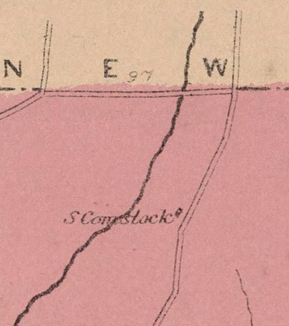
Where the Five Mile River crosses the border between New Canaan and West Norwalk, there is an old mill pond and mill run that Mary Gai has pointed out. A dam and mill pond can be seen from Meeting Grove Lane. A driveway goes over the dam. There is a mill run from the mill pond that goes under Meeting Grove Lane, runs south along the Lane, goes back under the Lane just before Old Rock Lanem and enters the river. There is no sign of a mill structure along the mill run. There is a sluice gate built into the dam.
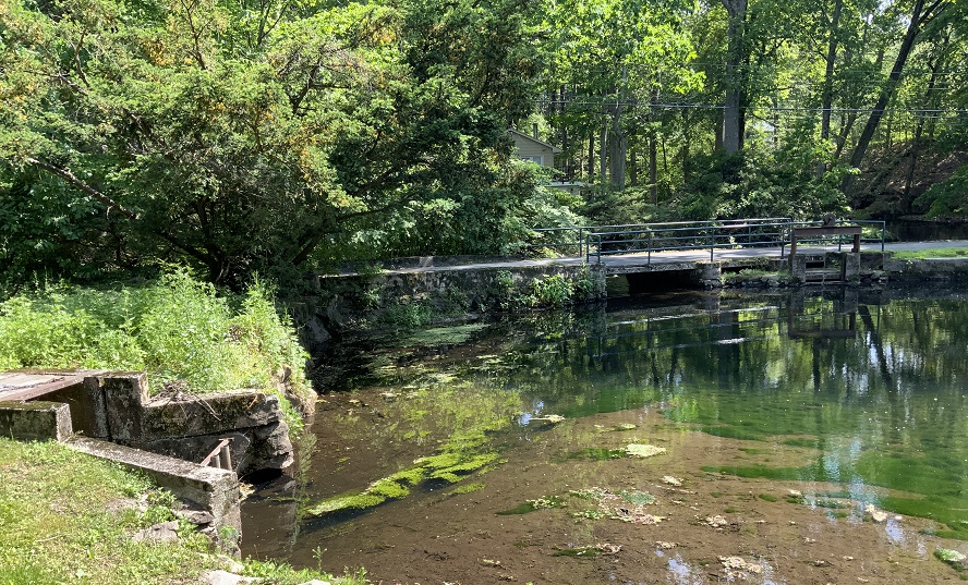
Mill pond on Five Mile River looking southwesterly toward the dam/driveway on the border between New Canaan and West Norwalk. The mill run is on the left. |
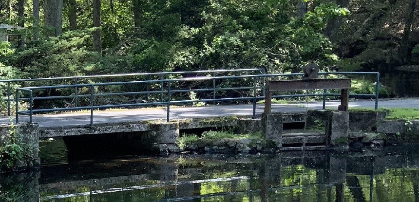
Close up of driveway, dam, and sluice gate. |
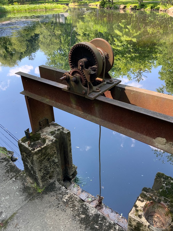
Close up of sluice gate valve, looking northwesterly into mill pond. |
Five Mile River looking north toward the dam/driveway on the border between New Canaan and West Norwalk. There is a ledge to the left. |
|
Northeasterly close-up of the the dam/driveway taken from the ledge. The sluice is just to the right of the ledge. |
|
This mill pond and mill are not shown on the 1867 maps of either New Canaan or Norwalk, so they must have been built after 1867.
West Norwalk
|
|
|
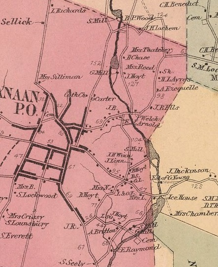
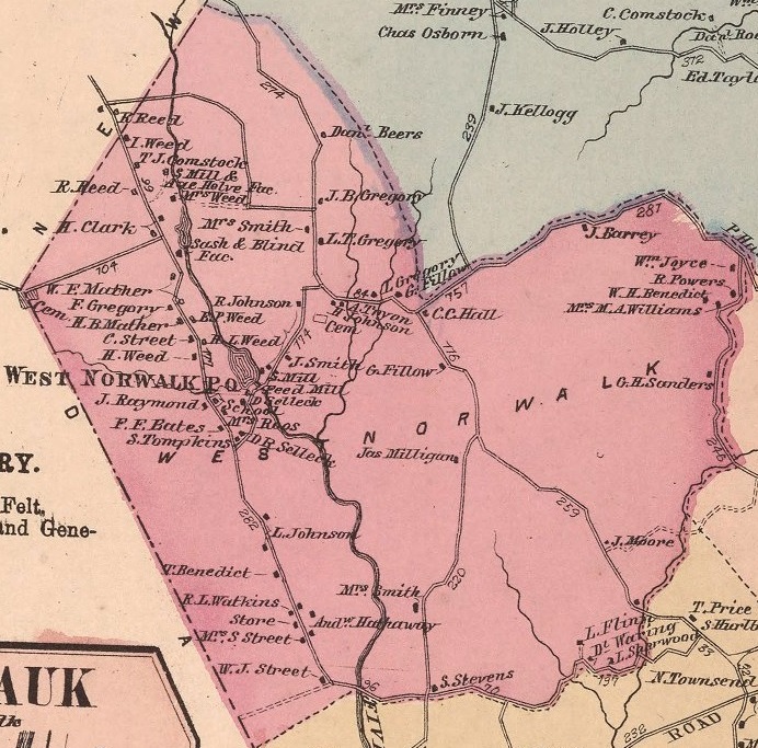
1867 Norwalk Map.
Two miles of the Five Mile River run through West Norwalk, crossed by Old Rock Lane at the top of the map, Fillow Street in the middle, and West Cedar Street at the bottom. The upper left corner is New canaan. The lower left corner is Darien.
Along the left side of the map is West Norwalk Road.
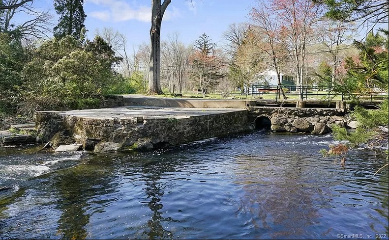
South of Old Rock Lane are a saw mill & axe helve factory. Farther south are a sash & blind factory just south of a pond now called Millard Pond. See: Dam Safety Inspection To the left of the sash & blind factory is Stephen Mather Road proceeding west from West Norwalk Road into Darien.
Still farther south are a saw mill and feed mill on a mill pond just north of Fillow Street and just south of a pond now called Florsheim Pond. See: Dam Safety Inspection. (See photo below.)
Old Rock Lane ends at Weed Avenue, which runs from the top of the map to Fillow Street. In the center of the map, Fillow Street meets Richards Avenue, which runs down the center of the map and crosses West Cedar Street at the bottom of the map.
The forked tributary in the middle left of the map is the Holy Ghost Fathers Brook, which enters the Five Mile River to the west of what is now St. John Cemetery.
In the center of the map, Scribner Avenue proceeding south east from Richards Avenue, passing the end of West Cedar Street, and crossing the Post Road in the bottom right corner of the map.
West Cedar Street runs across the bottom of the map from West Norwalk Road to Scribner Avenue.
At the bottom of the map, east of Richards, is Keeler Avenue proceeding south from West Cedar Street. The forked river in the bottom right corner is Keeler's Brook, with flows into the File Mile River.
|
|
Florsheim Pond Dam at Fillow Sreet
Florsheim Pond dam, from Fillow Street. |
Old McDonald's Farm
Old McDonald's Farm was on the north side of the Post Road at the Darien-Norwalk town line, where the Post Road crosses the Five Mile River. It had a petting zoo, a bakery, a restaurant, and an amusement park from 1955 to 1979.
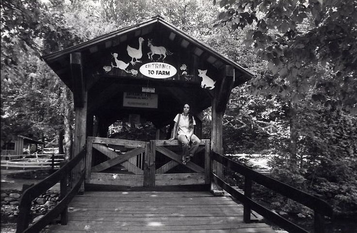 Covered bridge across the Five Mile River at Old McDonald's Farm. Covered bridge across the Five Mile River at Old McDonald's Farm. |
|
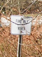
Sign for the Five Mile River on Connecticut Avenue (the Post Road) in Norwalk |
|
Old Post Road and Old Red Mill
|
|
From 1789 Colles atlas, Map 4, page 7, showing the Old Post Road, now Old Kings Highway North, the Red Mill ( Grist *), the Five Mile River (southbound squiggly arrow), and 48 miles from Federal Hall. Present day streets: Richards Avenue to the north (A to Canaan) and Rowayton Avenue and Raymond Street to the south.
George Washington is known to have crossed the Five Mile River when he traveled on the Old Post Road in Middlesex (Darien) in 1756, 1775-76, and 1789, as Colonel, General, and President.
See: Red Mill on the Old Post Road
|
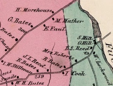
1867 Darien Map. Saw and grist mills on the Five Mile River in the Five Mile School Ditrict of Darien, on the present-day Old Kings Highway North (Old Post Road).
From the 1870 census for Darien, page 26:
John L. Reed, 56, farmer
Matilda Reed, 47, keeping house, born in England
Mary, 19, at school
Howard, 15, at school
Richard Bates. 59 farmer
Hannah Bates, 70, keeping house
Sally Roberts, 71, keeping house
Charles N. Roberts, 31, farmer, born in New York
Sarah Richards, 90
Rosa Schullen, 35, domestic servant, born in New York
Henry Weeks, 62, millwright, born in new York
Lewis L. Reed, 49, farmer
Phebe M. Reed, 38, keeping house, born in New York
Frances A. Reed, 15, at school
|
|
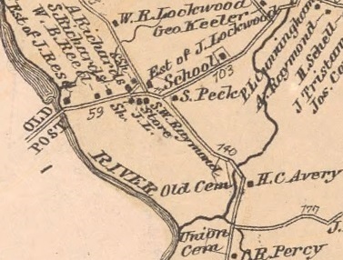
1867 Norwalk Map. Five Mile River, on the present-day Flax Hill Road (Old Post Road).
|
|
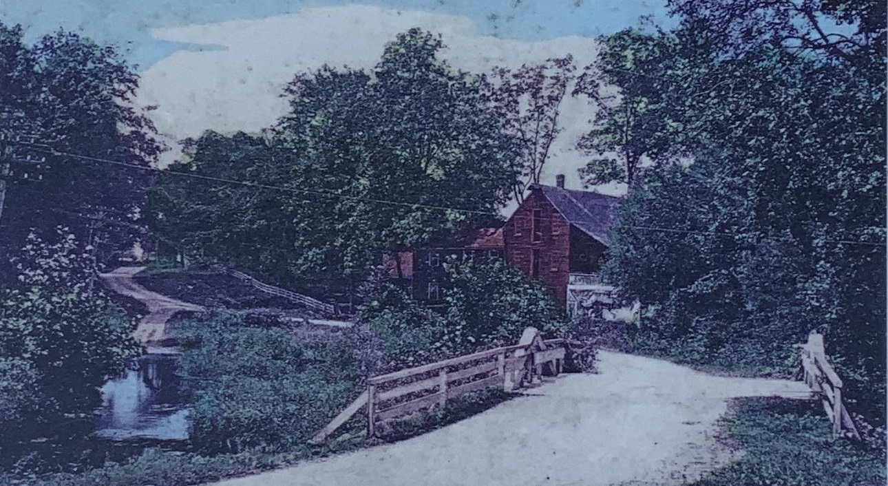
1894 photo of the Old Red Mill, enhanced by the Norwalk Historival Society and displayed at Brookside/Five Mile River Cemetery on Rowayton Avenue. Shot southwesterly from the Norwalk side of the Five Mile River bridge. In the foreground, the non-macadamized old Post Road (called the Farm Road in the 1900 census) crosses an A-frame bridge over the river. The road winds past the grist mill up the hill toward Raymond Street.
The mill building is center right. The mill run and wheel are under the roof on the right side of the building. The mill is three stories high. At the top is a hoist that would lift grain to the top floor.
Two utility poles can be seen at the far left. The first municipal electric plant in Connecticut began operating in the City of South Norwalk in 1892. Between the utility pole and the bridge is the mill run flowing back into the Five Mile River. To the left of the mill is a house built in 1880 that is today at 222 Old Kings Highway North. A long white fence parallels the road toward Raymond Street, probably starting in front of the house. See Unenhanced photo |
Below is a 1934 aerial photo provided by Greg Smith who grew up at 11 Richards Avenue. Old Kings Highway North/Flax Hill Road (Old Post Road) snakes across the middle. The Five Mile River bridge is in the center. Old Kings Highway North is to the left of the bridge. The first house south of the bridge is 222 Old Kings Highway North. Flax Hill Road is to the right. Shadybrook Lane angles up and left from Flax Hill Road at the bridge. Raymond Street is on the lower left, Richards Avenue is on the upper right. Traendly rose greenhouses are at bottom right. The Post Road is at the very top left. Getner Farms are upper right. There was no I-95.
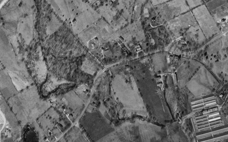
1934 aerial photo. |
2022 map of appriximately the same area as the above 1934 aerial photo. |
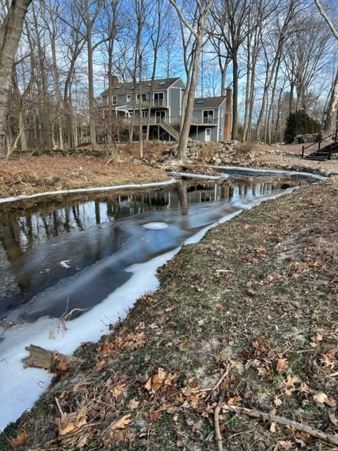
Down river photo of the back of 230 Old Kings Highway North by Gina Nichols on a cold February 4, 2023. |
|
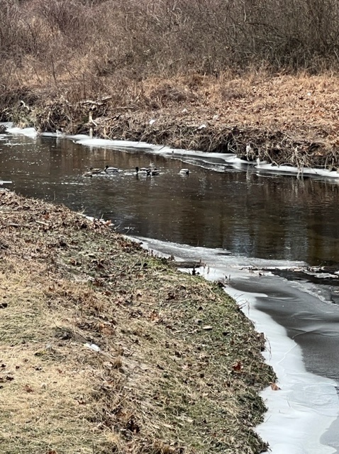
Up river photo of brave Mallards by Gina Nichols on a cold February 4, 2023. |
|
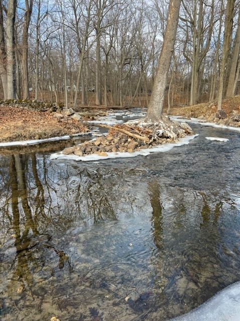
Down river photo by Gina Nichols on a cold February 4, 2023. |
|

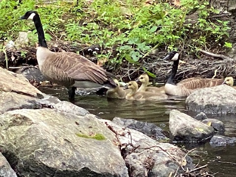
Canada geese with six goslings by the mill pond of the Old Red Mill, spring 2022. Photo by Anthony Zangrillo. |
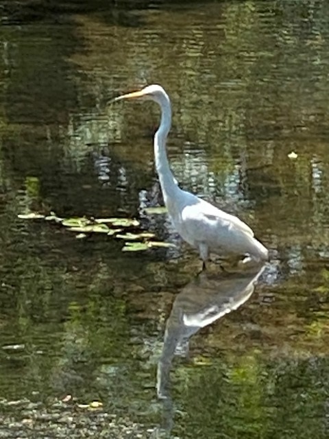
Egret on the mill pond of the Old Red Mill, summer 2020. Photo by Anthony Zangrillo. |
|
Canada geese family on the mill pond of the Old Red Mill, spring 2020. Photo by Anthony Zangrillo. |
|
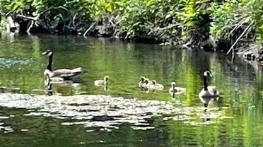
Canada geese family on the mill pond of the Old Red Mill, spring 2021. Photo by Anthony Zangrillo. |
|
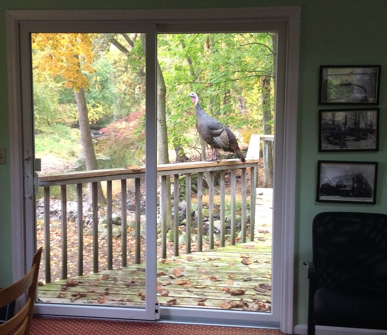
Wild turkey overlooking the mill pond of the Old Red Mill, with photos of grist mill and saw mill on the wall at 230 Old Kings Highway North, Darien, October 2020. Photo by Peter Biggins. |
|
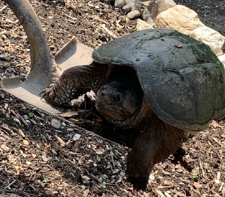
Snapping turtle that climbed up from the river to the Zangrillo back yard. "He must have been 40-50lbs; took a lot to carry him down and put him back in the river." June 2021. Photo by Anthony Zangrillo. |
|
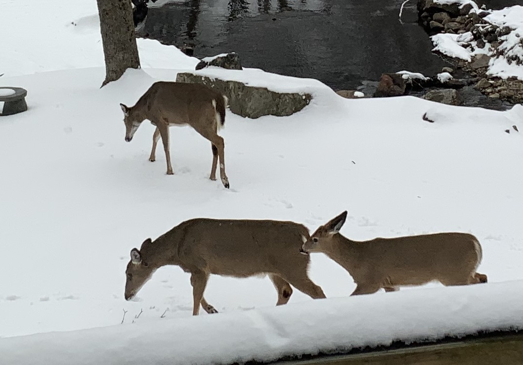
Three of six deer on the afternoon of February 12, 2025. |
|
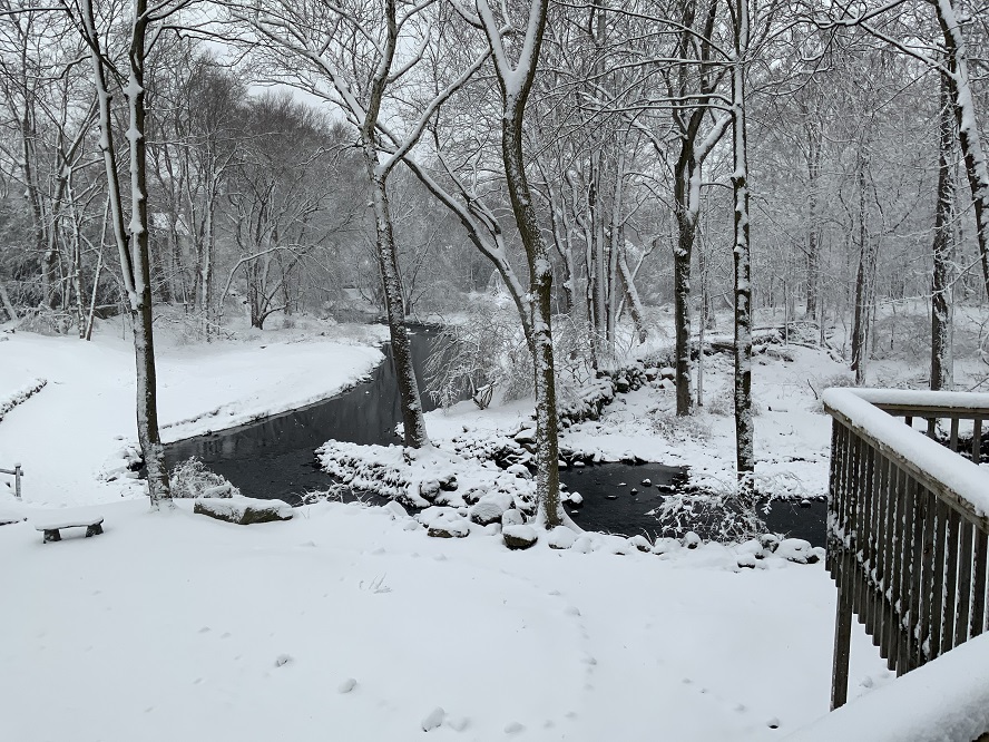
Five inches of snow on the morning of February 28, 2023--the only snow that amounted to anything that winter. |
|
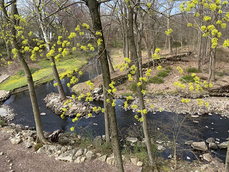
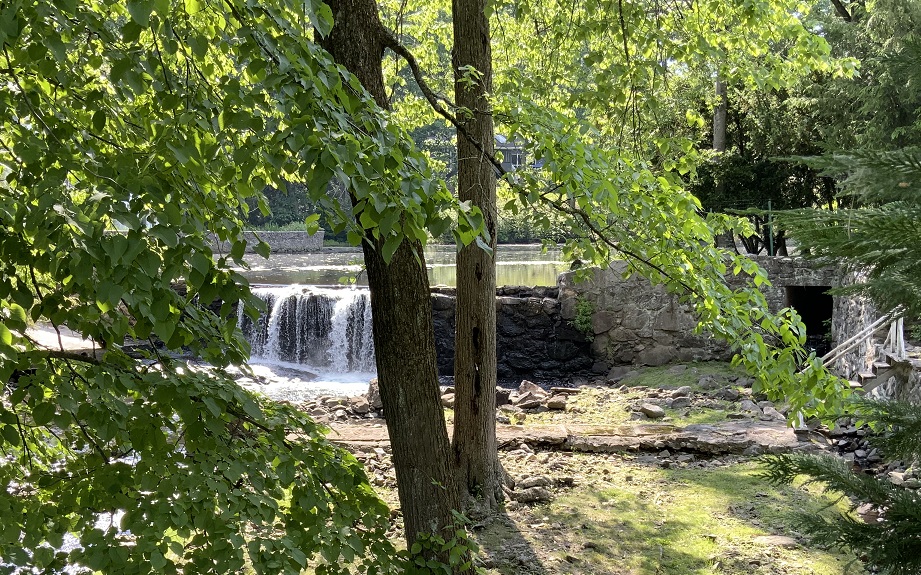
Up river view of maple blossoms, April 12, 2023. In the background can be seen the remains of the dam for the Old Red Mill. |
|
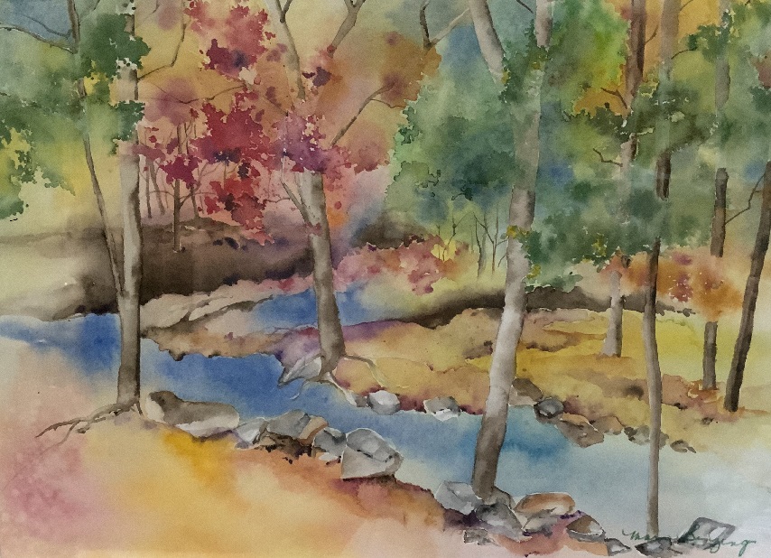
Painting by Sister Mary Benzing, SSJ. |
|
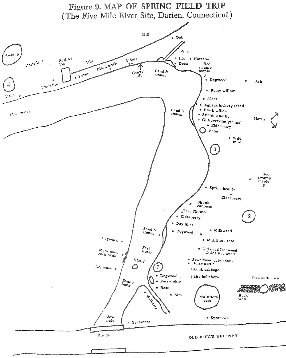
Map from The River Book. View of the Five Mile River looking south from Old Kings Highway North. Source: The River Book, A Study Guide to the River and Its Environment, The Junior League of Stamford-Norwalk, Third Edition, 1977, p. 51. |
Traendly Flood Plains
The Traendly Flood Plains property was transferred to the Darien Land Trust in 1977. It is 13.22 acres of river flood plains feeding Five Mile River. It has a population of diverse wetland species and is a refuge for many types of wild life. In the 1980s and 1990s it was used extensively in the spring and fall for river study programs for Darien and Norwalk 4th graders and other groups.
Brookside/Five Mile River Cemetery
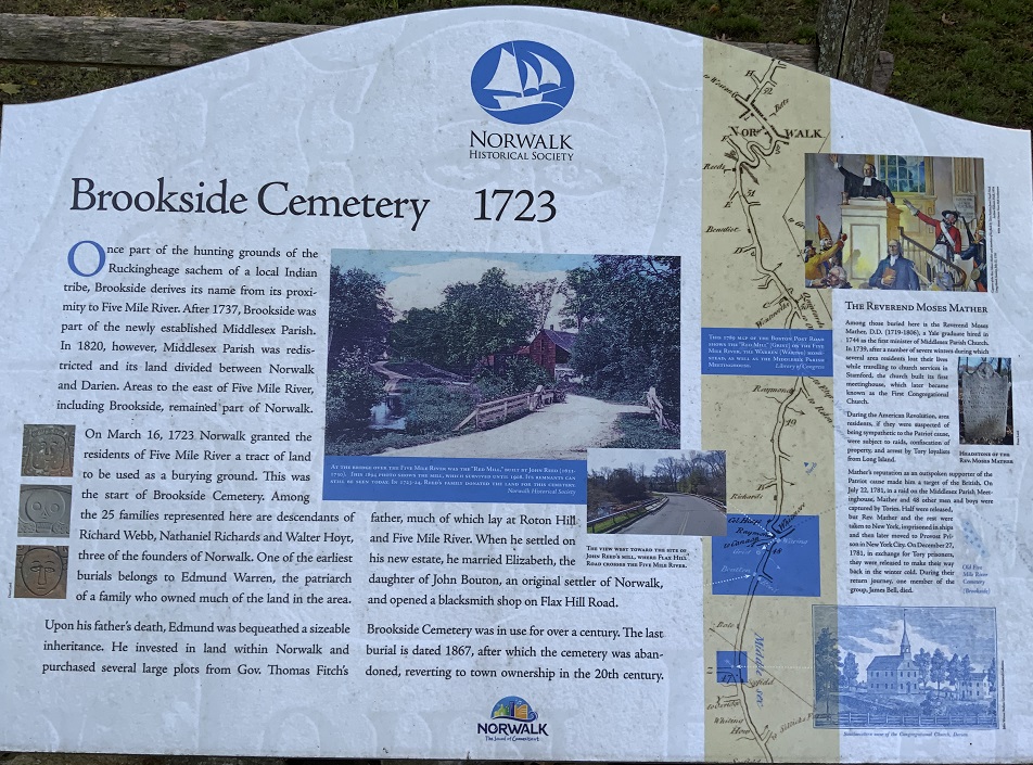
Sign at Brookside/Five Mile River Cemetery on Rowayton Avenue, south of Flax Hill Road, showing the Red Mill, the 1789 Colles map of the Kings Highway Road, and information about the Reverend Moses Mather (1719-1806), who is buried in the cemetery. Source: Norwalk Historical Society. See larger image. |

Beneath this stone Lies the body of
REV. MOSES MATHER, DD Pastor of
the first church In Middlesex who
died Sept. 21, 1807, aged 87 in the
65 year of his Ministry Death is a
debt to nature due. Which I have
paid & so must you. |
Brookside/Five Mile River Cemetery on Rowayton Avenue, south of Flax Hill Road, is the final resting place of Reverend Moses Mather, the first minister at the Middlesex Parish, now the First Congregational Church of Darien.
Rev. Richard Mather 1596-1669. Immigrated with a company of pilgrims, from Manchester, England, to Masachusetts in 1635 on the ship James
Rev. Increase Mather 1639-1723. Son of Rev. Richard Mather. Brother of Timothy Mather. Attended Harvard College and Trinity college Dublin. Sixth president of Harvard College. Father of Cotton Mather
Timothy Mather 1628-1684. Came over from England with his father Rev. Richard Mather. Brother of Rev. Increase Mather
Richard Mather 1653-1688. Son of Timothy Mather. Moved from Massachusetts to Lyme, Connecticut, in 1687
Capt. Timothy Mather 1681-1755. Moved to Lyme with his father Richard Mather
Rev. Moses Mather 1719-1806. Son of Capt. Timothy Mather. Graduate of Yale College in New Haven. Moved from Lyme to Darien, Connecticut, in 1744 to become the first minister at the Congregational Church, a position he held until his death 62 years later. Imprisoned several times as a patriot during the American Revolutionary War. Buried in Brookside/Five Mile River Cemetery on Rowayton Avenue, south of Flax Hill Road
Joseph Mather 1753-1840. Son of Moses Mather. Built the Mather Homestead in 1778, 2.3 miles north of the Congregational Church, on 100 acres of farmland inherited by his mother Hannah Bell
Joseph Mather 1789-1864. Son of Joseph Mather
Joseph Wakeman Mather 1820-1905. Son of Joseph Mather
Stephen Tyng Mather 1867-1930. Son of Joseph Wakeman Mather. Considered the father of the modern national park system. First Director of the National Park Service
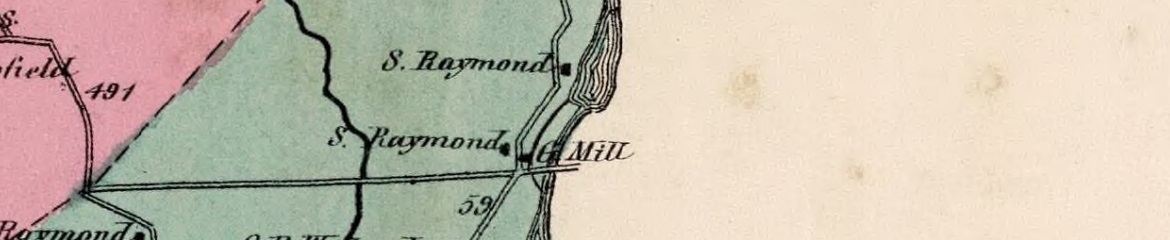
Chasmer's Pond in Darien/Rowayton
1867 Norwalk Map. Feed mill and sash, door & blind factory on the Five Mile River in South Five Mile River section of Norwalk, on the present-day Rowayton Avenue, south of the New Haven Railroad. |
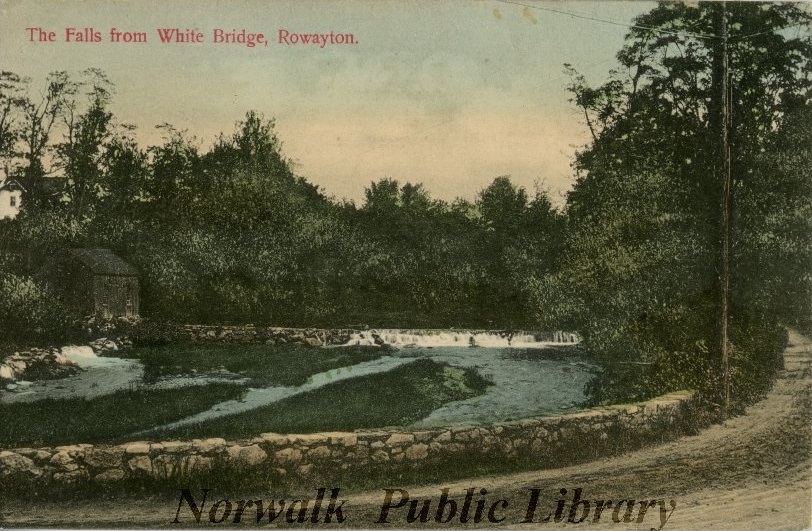
New York, New Haven and Hartford Railroad crossing the Five Mile River in the 1880s. The falls at Chasmer's pond dam are visible under the bridge. Source: postcard at the Norwalk Public Library. |
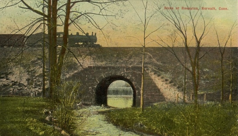
White Bridge
1867 Darien Map. Grist mill on the the Five Mile River at "the top of the salt." Between Raymond Street and the river. North of Tokeneke Road at White Bridge. |
Falls over the grist mill dam on the Five Mile River at "the top of the salt." White Bridge in the foreground. Source: postcard at the Norwalk Public Library. |
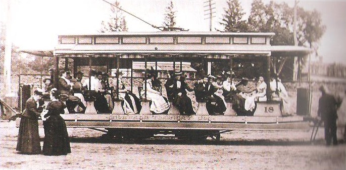
Open-sided car of the Norwalk Tramway Line that ran between Darien and Norwalk, crossing the Five Mile River at White Bridge from 1893 to 1933. Source: The Story of Darien, Connecticut, by Kenneth M. Reiss, 2009, p. 192. |
Middle and South Five Mile River in Norwalk (Rowayton)
1867 Norwalk Map. The area south of West Norwalk and north of Rowayton is called Middle Five Mile River. Turn Pike Road is the new Post Road. Old Post Road is Flax Hill Road. The road to the north is Richards Avenue. The road to the south is Rowayton Avenue. "Old Cem." is Brookside/Five Mile River Cemetery
(Rev. Moses Mather 1719-1896), just west of Keelers Brook. |
|
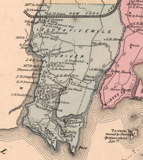
1867 Norwalk Map. Rowayton is called South Five Mile River. The Five Mile River harbor on the left was central to shipping businesses from the early 1800s through the early 20th century. South of the shipping businesses were homes of many oystermen and boat builders. Roton Point is at the bottom center. In the late 1880s, this popular picnic spot began to expand its entertainment offerings aided by a trolley system that brought people to the site every 20 minutes and, eventually, large steamships that would ferry thousands of people to the park every day. In Wilson Cove on the right is Tavern Island, owned by the Norwalk Oystermans Association in 1867. In the 1920s, Tavern Island was the home of Billy Rose, a famous entertainer and bootlegger. Lillian Hellman completed her Academy Award-nominated screenplay The Little Foxes while living on Tavern Island in 1939. |
|
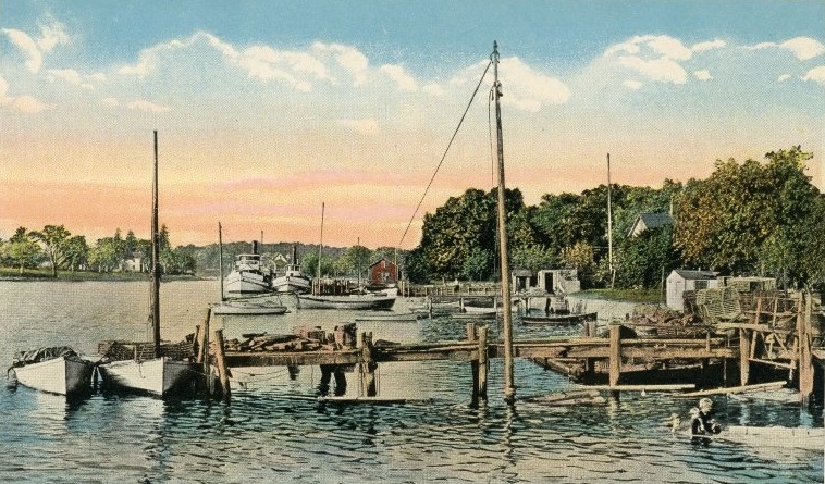
The Five Mile River harbor looking north with sailboats and steamboats at docks. Lobster pots are piled in sailboats and on the pier. There are boys in rowboat at right. Source: postcard at the Norwalk Public Library. |
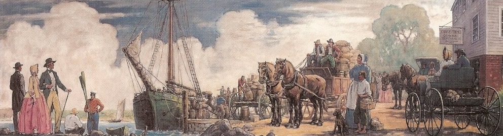
WPA mural "Packet Day at Five Mile River" by George Avison, 1937. Restored circa 1986. Located at the Rowayton Library. Packet sloop "Chief" loading produce for the new York market in the Five Mile River at Rowayton. Source: Rowayton Historical Society. |
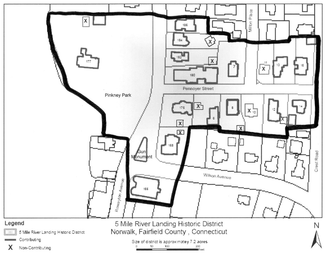
Five Mile River Landing Historic District. The Five Mile River Landing Historic District is a residential neighborhood of
small to medium-sized domestic and public buildings dating from the late 18th
century through the early 20th century. It is the residential remnant of a
larger 19th century maritime village. The district is located on the eastern
bank of the Five Mile River in the village of Rowayton, in the southwestern
part of the City of Norwalk. It includes Rowayton Avenue from
the northern edge of Rowayton's business district to Jo's Barn Way. The
district also includes Pennoyer Street. In addition to relying on the
geographic boundary of the Five Mile River, the district's boundaries were
drawn from the historic development patterns of the area - as early maps
demonstrate, the 19th-century residential corridor along the Five Mile River
did not extend beyond these streets in this area.
With its proximity to the river, the district is low lying. The high point is
located at the eastern end of Pennoyer Street, which rises from Rowayton Avenue
next to the river to the top of a small ridge. The streets are open and
relatively free of trees, adding to the sense of a coastal setting. The
buildings are located on a mix of small and medium sized lots with most of them
located quite close to the street and to each other. The one exception to this
is the Seeley-Dibble-Pinkney House at 177 Rowayton Avenue, which sits closer to
the river than the road on a large lot relatively far away from its neighbors.
The Five Mile River Landing Historic District exemplifies a typical 19th
century residential district, with a mix of styles from throughout the period.
The buildings are wooden, mixing both timber- and balloon frames, and range in
height from 1.5 to 3.5 stories. They are clad in clapboards, shingles, stucco,
or a mix of these materials. In addition to the domestic buildings and their
outbuildings, the proposed district also includes one church, a boathouse, a
carriage house, and a building constructed as a hotel.
The buildings also reflect a variety of styles. While many of the buildings
in the district are vernacular, several are good examples of specific styles.
The Federal style is represented by the side-entry Seeley Dibble Pinkney house
(c. 1820) at 177 Rowayton Avenue. A simple example of the Greek
Revival can be found at 186 Rowayton Avenue, the Captain William Sammis House
(c. 1842). 12 Pennoyer, the Baptist Parsonage (c. 1872), was
constructed in the Second Empire style. 8 and 14 Pennoyer
Street, the James E. Stevens House (c. 1872) and the Corvino L.
Ogden House (c. 1888) respectively, were built in the Queen Anne style. The
Methodist Church (c. 1868) was originally constructed as a simple, clapboarded
building with an arched, tripartite window above the door and a small rose
window in the gable. In 1908 it was thoroughly renovated into a Late Gothic
Revival-style building.
In addition to the buildings, the district includes two open spaces. Near the
southern end of the district a town park (established in 1966) includes two
contributing buildings at its northern end and the contributing site of a
former shipyard at its southern end. In 1901, a traffic island was created at
the intersection of Rowayton Avenue and Wilson Avenue, near the southern
boundary of the district, for a monument topped by a naval artillery piece to
commemorate Rowayton's Civil War dead. The original inscription reads as
follows:
Memorial Gun
Reminding us of the Heroic Deeds of Our
Soldiers and
Sailors of the Republic in the War
Of the Rebellion for the
Preservation of the Union
Erected 1901
From U.S.S. Tallapossa
Plaques were subsequently added to the base of the monument to honor the
citizens of Rowayton who died during World War I and World War II. (See: The Historical Marker Database)
There are 27 buildings, 1 site, and 1 object in the district (exclusive of
sheds and other minor outbuildings). 19 (66%) contribute to the district.
Among the non-contributing structures are seven garages, two modern houses and
a small boathouse.
The Five Mile River Landing Historic District demonstrates the development
pattern of the domestic portion of a Connecticut riverine maritime village as
it grew from an area of scattered farm houses to an oystering village and
seasonal vacation spot and, finally, into a year round suburb. Since its
founding, Rowayton has looked to the Five Mile River and Long Island Sound for
sustenance. The area's earliest settlers turned to the river and Long Island
Sound for fish, salt hay, and transportation. As the area developed, the
importance of coastal trade and shipbuilding expanded in Rowayton. This was
followed by notable growth in the oystering industry in the mid-19th century as
well as the beginning of the area's time as a vacation destination. By the
beginning of the 20th century oystering began to decline and vacationers
started to build more permanent houses, changing the area's character from
seasonal to suburban. (Elements of all of these phases of the village's
development can still be seen in the historic district.) Throughout this time,
the driving force behind all of these developments was the area's shoreline
location. This pattern - moving from subsistence agriculture and fishing to
trade and commercial fishing, or in the case of Rowayton aquaculture, to
tourism and finally, to a suburb - is a common one along the Connecticut
coastline. The district focuses on the area's domestic buildings built during
the 19th century, when it enjoyed its greatest growth, although there are
examples of buildings from each phase of the area's development.^ Taken
together the district represents a significant and distinguishable historic
entity.
The district was first divided for settlement in 1705; 8 acres in the district
were given to John Raymond. A local historian suggests that the properties
were most likely granted prior to this point but not officially recorded until
1705. By the end of the 18th century the area was populated with farmers and
watermen; the Raymonds appear to have been farmers.
The oystering business reached its peak in the quarter century between 1885 and
1910. Coinciding with this boom in oystering was the advent of streetcar
service to Rowayton in 1890. This amenity, along with the already extant
trains and the soon to be prevalent car, prepared Rowayton for the final
chapter in its history. In the early years of the 20th century the villagers
began to look away from the water for their livelihood and began commuting to
jobs in South Norwalk and beyond.
By the end of this period the character of the area around the intersection of
Pennoyer Street and Rowayton Avenue was set, with a few additions it would
remain a reminder of fin de siecle Rowayton.
Five Mile River Road in Darien
The start of Five Mile River Road from Tokeneke Road. The Five Mile River curves off to the left. Old Farm Rod branches off center left. From photo taken in 1890. Source: The Story of Darien, Connecticut, by Kenneth M. Reiss, 2009, p. 30. |
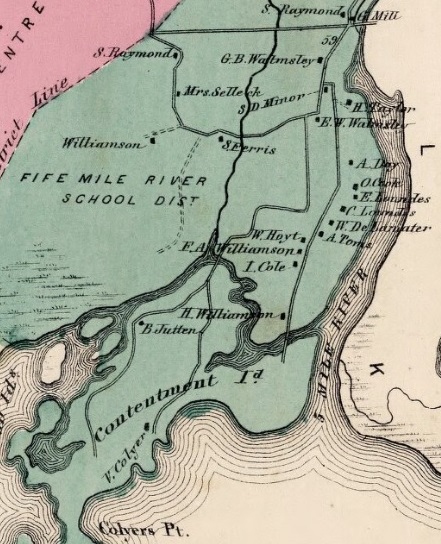
1867 Darien Map. Five Mile River Road, just west of the Five Mile River. The Tokeneke school district was then the Five Mile River. Contentment Island, including the house of Vincent Colyer on the highest point on the island, where John Frederick Kensett lived and painted scenes across the mouth of the Five Mile River. |
|
1870 Census.Following is information from The U.S. Census of 1870 that matches up with houses on part of the 1867 map of Darien shown on the left, which includes Five Mile River Road and Contentment Island. Shown is name, age, occupation, value of real estate, and state where the person was born. Not shown below are spouses and non-working children.
Occupation: 9 oysterman, 6 farmer, 4 house carpenter, 3 ship carpenter, 2 clerk, 1 shipwright, 1 Indian agent.
State of birth: 13 Connecticut, 11 New York, 2 New Hampshire, 1 Maine.
1870 U.S. Census, Darien, Connecticut, page 32
- Stephen Raymonf, 61, farmer, $10,000, Connecticut
1870 U.S. Census, Darien, Connecticut, pages 29-31
- Mary Selleck, 78, $8,000, Connecticut
- William S. Selleck, 55, farmer, Connecticut
- Alanson Williamson, 55, ship carpenter, $2,000, New York
- Satt Williamson, 21, house carpenter, New York
- Andreus Millspaugh, 31, house carpenter, New York
- Benjamin Williamson, 18, clerk, New York
- Stephen Ferris, 87, farmer, $12,000, Connecticut
- John Ferris, 65, farmer, Connecticut
- Wm. S. Walmsley, 48, farmer, $8,000, Connecticut
- Stephen E. Walmsley, 26, farmer, Connecticut
- Hiram G. Taylor, 45, oysterman, Connecticut
- Hiram B. Taylor, 22, oysterman, $2,000, Connecticut
- Olever Cook, 45, oysterman, $3,500, Connecticut
- Stephen Cook, 19, oysterman, Connecticut
- Edward Lowndes, 52, oysterman, $2,000, New York
- Charles Lowndes, 45, oysterman, $5,000, New York
- Wm. B. Delemater, 70, shipwright, $1,600, New York
- Augustus Thomes, 52, clerk or agent, $2,500, Maine
- Gardner F. Thomes, 22, house carpenter, Conneticut
- William Hoyt, 41, house carpenter, $2000, Conneticut
- Frank Williamson, 37, oysterman, $2,000, New York
- Henry T. Cole, 62, ship carpenter, $2,000, New Hampshire
- Dexter K. Cole, 31, oysterman, $2,000, New York
- John H. Cole, 29, oysterman, New Hampshire
- Hickson Williamson, 64, ship carpenter, $3,000, New York
1870 U.S. Census, Darien, Connecticut, page 47
- Vincent Colyer, 45, Indian agent, $4,000, New York
|
|
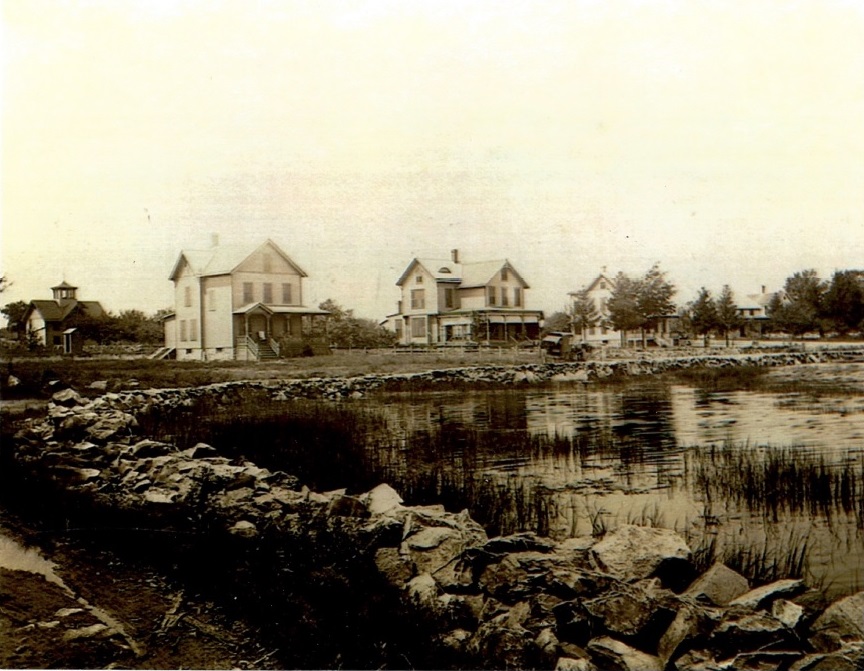
Houses at 120, 118, 116, and 114 Five Mile River Road viewed from southeast of the turnaround. High tide. The building on the far left is a barn. Circa 1900. Source: Michael Cattano. |
In December 2020, J. Chris Hall wrote: "I just recently happened upon your article about the Five Mile River and found it quite fascinating. I grew up on the river, first at 118 Five Mile River Road (1951-1958) and later at 110 Five Mile River Road (1959-1969). My mental mind set was that the river ended at the White Bridge. This was, no doubt, because this was where navigation ceased. The only exception to my myopic vision up stream from the bridge was the unique residential property that was on the Darien side of the river but was only accessible via a ramshackle private bridge from Rowayton [ed. note: Carolyn Place, no longer ramshacle]. Our school bus would cross into Rowayton to pick up students. Your narrative and pictures are great. The picture that you date to about 1900 was of interest to me as it included what is now 118 Five Mile River Road. (Second house from the left) The barn shown in the picture could be the one we used for making wooden rafts to 'explore' amongst the mountains of reeds which used to cover the west side of the river. Thanks for making my day!"
"Five Mile River, Rowayton, 1920" by the noted marine artist John Stobart. Oil on canvas, 1986. This view looks southeast from Darien towards Rowayton and Long Island Sound. Oyster boats are plying their trade, catching the tide on a late morning in the early fall. This image appears on the inside front and back covers of Rowayton on the Half Shell by Frank Raymond, 1990. See Kensington-Stobart Gallery. |
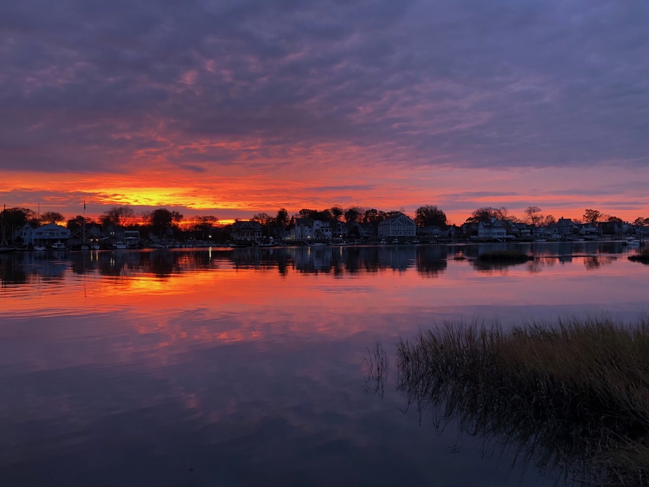
Sunrise over Five Mile River harbor. High tide. November 2019. Photo by Gayle Campbell. |
Paintings by by John Frederick Kensett
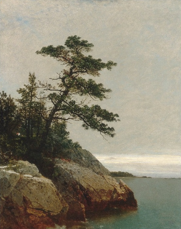
"Old Pine, Darien, Connecticut by John Frederick Kensett (1816-1872). From the collection of the Metropolitan Museum of Art, New York, New York. Painted from the southeast shore near the artist s studio on Contentment Island. Visible in the painting is the profile of Roton Point, with Pine Point beyond. Kensett built a studio on the high southeastern bluff of Contentment Island, overlooking the Fish Islands and Long Island Sound; it was a short walk from the house. See John Kensett and the Connecticut Shore. |
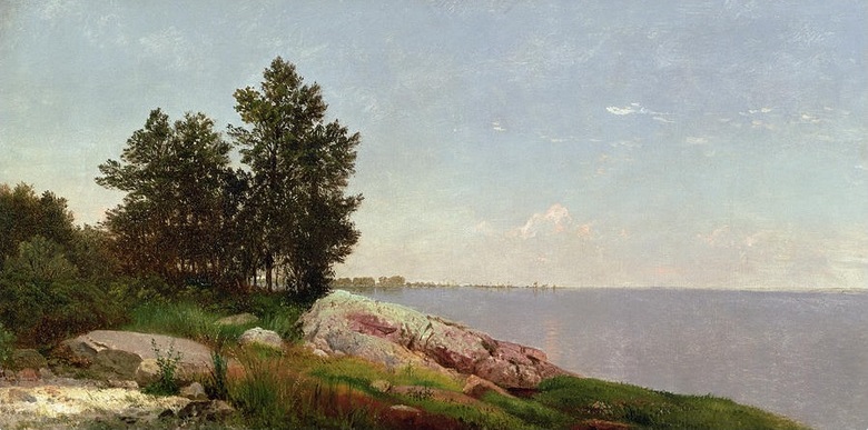
"Study on Long Island Sound near Darien, CT by John Frederick Kensett (1816-1872). In the collection of the Amon Carter Museum, Fort Worth, Texas, but sold in 2003. Painted from a lower elevation, on the southern shore of Contenment Island, looking toward the low sandy spit at the western end of Sheffield Island. See John Kensett and the Connecticut Shore. |
In October 2020, Dennis Dixon wrote: "I'm 67 and I grew up on Tinywood Road (in the "backcountry"/"wilderness" of Darien), and spent many happy hours at the Tokeneke Beach Club and the Wee Burn Beach Club, and I have always loved going over File Mile River and down through Rowayton. Reading your wonderful blog about Five Mile River (and then playing with Google Maps) felt great.
"The reason I hit your blog is artist John Kensett, and his "Study on Long Island Sound near Darien, CT" painting. It is no longer in the collection of the Amon Carter Museum of American Art, Fort Worth, TX - they deaccessioned (sold) it through Christie's in 2003. That is one reason why I travel around and visit museums - to see this stuff (Hudson River School artists, Winslow Homer) before they decide to either sell them or lock them up for good.
"Keep up the good work, and Stay Safe!"
Aerial Views of the Mouth of the Five Mile River
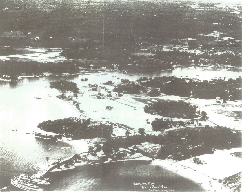
Northwesterly aerial photo of Roton Point Park (1880-1941) on Long Island Sound in the foreground and the Five Mile River harbor in the background. The southern half of Five Mile River Road runs along the far right side of the river. High tide. Circa 1930. Source: Michael Cattano. |
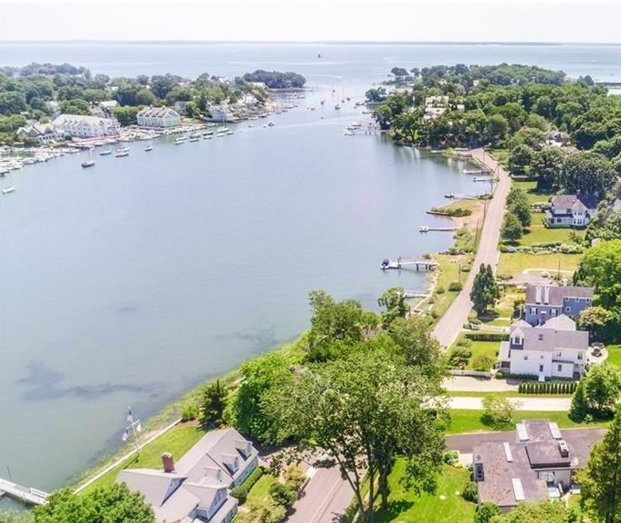
Southerly drone photo of the Five Mile River and the southern half of Five Mile River Road. The Greens Ledge Light and Long Island can barely be seen in the background. High tide. |
Loading Rock
In August 2020, Michael Cattano provided notes of Marian Castelli, Darien Town Historian, about Loading Rock, which was once a small center of commerce/port for Oyster Harvesting:
To the east of Contentment Island, at Five Mile River, there were two dramatic, rocky projections - one at the mouth of the river, on Butler's Island (now joined to Contentment Island by a causeway), and the other slightly upriver, formerly known as the Loading Rock, because it was used for loading cargo sloops in the 18th and 19th centuries. The Loading Rock has been a local landmark for centuries:
At Five Mile River, oyster sloops took on their cargoes at Loading Rock, a huge boulder, part of which still remains a landmark on the west side of the river.
From Connecticut Place Names by Arthur Hughes and Morse S. Allen, 1988, p. 109.
Loading Rock: A large rock on the west bank of Five Mile River near 125 Five Mile River Road, used as landing by packet books [which sailed up the river from the 1700s through the late 1800s].
From Rowayton of the Half-Shell by Frank Raymond, 1991.
Greens Ledge Light and Long Island
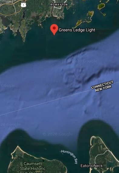
Google map of Greens Ledge Light, built in 1902. One mile south of the mouth of the Five Mile River and 5.6 miles north of Eatons Neck Point on the North Shore of Long Island. |
|
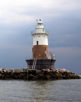
Greens Ledge Light. Legend has it that Greens Ledge was named after a pirate Green, who sailed with the infamous Captain Kidd. When Green was captured by authorities of the day, he was reportedly executed and his body fastened to the ledge in chains as a dire warning to others thinking of entering the buccaneering trade. Years later, a lighthouse would be established on the ledge as a warning to vessels seeking to enter Norwalk Harbor. See Lighthousefriends. |
|
Five Mile River Watershed
Once home to thriving populations of wild and native trout - indicator species that require the coldest, cleanest water - the Five Mile River has become degraded over time due to land use changes and climate change. See: Trout Unlimited.
The Five Mile River Watershed encompasses approximately 7,995 acres of land. The watershed includes the areas around the streams & brooks that feed the Five Mile River (tributaries), such as Holy Ghost Fathers' Brook and Keelers Brook. Source: City of Norwalk |
|
|
|
|
 The Five Mile River